Monday 18 May 2015

Weather & Climate- British Isles Climate Case Study

The Great Storm, Southern England, 1987

Causes

  • October 1987 started off fine and dry but quickly became unsettled and wet. In the days before the storm low pressure lingered off the west of Ireland, producing spells of wet weather across Britain. 
  • Warm air from Africa met cold air from the Atlantic Ocean, causing an intense depression.
  • The depression developed over the Bay of Biscay on 15th October and moved northwards.
  • The deepening of the depression to 958mb was believed to be the result of a very strong jet stream and warming over the Bay of Biscay which together probably released latent heat energy warming the air even more and reducing pressure even further. 
  • Weather forecasters thought it wouldn’t reach England, but by midnight it had changed course and moved towards the south coast.
  • It was in fact not a hurricane, but a depression.
  • Winds were over 100 km/hour and on the coast and winds reached gale force 11.
  • The central pressure was 953 mb.
  • There were rapid changes in temperature as the warm front passed over eg. in Farnborough 8.5°C to 17.6°C in 20 minutes.

Impact

Social
  • 18 people died in the UK
  • Many houses suffered damage leading to homelessness
  • Communications were broken with trees falling on railway tracks and roads, and damage to power lines leading to blackouts.
  • 5 million homes were without electricity.
Economic
  • Numerous small boats were wrecked or blown away, with one ship being blown over and a Channel ferry was blown ashore
  • Caravan parks were wrecked
  • Cost £2 billion in insurance claims, so premiums went up for everyone next year
  • Fire brigade had 6000 calls in 24 hours
  • Buildings collapsed
  • Losses from storm totalled £1.4 billion in the UK. 1 in 6 households in SE England submitted insurance claims.
Environmental
  • 15 million trees were uprooted, including 6 of the famous oaks trees in Sevenoaks
  • Loss of habitats and biodiversity but fallen trees provided new habitats for some animals
  • Some plants benefited as there was more light on the forest floor allowing them to grow

Prediction

  • The storm of 1987 gained an almost mythical status as the storm that proved the weathers forecasters wrong. 
  • In reality this ‘1 in a 100 years’ event was very difficult to predict due to the speed of the drop in pressure. 
  • An evening weather forecast by the MET office correctly described the current state of the depression & its likely path. 
  • The veering of the storm to a more northerly track was noticed too late to allow for effective warning. 
  • Most people were asleep so wouldn't have heard the additional warnings.
  • Warnings of severe weather had been issued, to various agencies and emergency authorities, including the London Fire Brigade. 
  • Perhaps the most important warning was issued by the Met Office to the Ministry of Defence at 0135 UTC, 16 October. It warned that the anticipated consequences of the storm were such that civil authorities might need to call on assistance from the military.
Criticism of the MET Office
  • Media reports accused the Met Office of failing to forecast the storm correctly. 
  • Repeatedly, they returned to the statement by Michael Fish that there would be no hurricane - which there hadn't been. 
  • It did not matter that the Met Office forecasters had, for several days before the storm, been warning of severe weather. 
  • The Met Office had performed no worse than any other European forecasters when faced with this exceptional weather event.
  • This storm wasn't officially a hurricane as it did not originate in the tropics - but it was certainly exceptional. In the Beaufort scale of wind force, Hurricane Force (Force 12) is defined as a wind of 64 knots or more, sustained over a period of at least 10 minutes. 
  • By this definition, Hurricane Force winds occurred locally but were not widespread.

Responses

  • Clear up took considerable time with emergency crews being drafted in from Northern regions where damage had been more slight.
  • Losses from storm totalled £1.4 billion in the UK. 1 in 6 households in SE England submitted insurance claims.
  • MET Office enquiry recommended that observational coverage of the atmosphere over the ocean to the S and W of the UK was improved by increasing the quality and quantity of observations along with refinements made to computer models used in forecasting.
  • A significant clean up of fallen trees was criticised by ecologists for removing damaged broad leaf trees that would have recovered with time. 

Wednesday 13 May 2015

Weather & Climate- British Isles Climate

Anticylones

Characteristics:
  • Anticyclones are characterized by high atmospheric pressure
  • Represented by closed isobars with pressure increasing towards the centre
  • move slowly and may remain stationary over an area for several days or weeks
  • isobars are far apart therefore there is little pressure difference between the centre and edges of the anticyclone
  • winds are weak and flow gently outwards in a clockwise direction in the northern hemisphere, anticlockwise in the southern hemisphere
Formation:
  • The air that descends from the upper atmosphere is cooler, drier and denser than air at ground level. 
  • As it descends it warms and can hold a lot of moisture leading to limited condensation and reduced rain. 
  • This stable air can cover several thousand KM and presents a gentle pressure gradient with weak winds blowing clockwise out from the centre of the high pressure area. 
  • The passage of anticyclones tends to be much slower than depressions. Weather can be days or weeks depending on the season.
Winter Anticyclones:
  • Cold daytime temperatures and freezing night-time temperatures as less isolation is available to warm the British Isles and the clear skies of a high pressure zone mean that the moderate gain of warmth during the day can be more than offset by rapid loss of heat at night.
  • Surface cooling frequently gives rise to radiation fog and frost which may persist because of the weak sunshine during the day. 
  • High levels of atmospheric pollution in urban areas caused by subsiding and no wind.
  • When dry cold polar continental air from central Asia and Europe moves across the North Sea it can bring heavy snowfall to eastern regions. 
Summer Anticyclones:
  • Hot daytime temperatures and warm night-time temperatures as clear skies allow maximum isolation producing temperatures of over 25 during the day time.
  • Generally clear skies, hazy sunshine in some areas.
  • Formation of dew & mist which clear quickly in the morning.
  • The east coast of Britain may have sea frets caused by onshore winds.
  • Thunderstorms when the air has high humidity.
Where blocking anticyclonic cells exist for days over Europe the deflection of warmer depressions away from Britain can bring dry freezing conditions in winter and heatwaves in summer.

Fog

Radiation fog:
  • Radiation fog usually occurs in the winter, aided by clear skies and calm conditions. 
  • The cooling of land overnight by thermal radiation cools the air close to the surface. This reduces the ability of the air to hold moisture, allowing condensation and fog to occur. 
  • Radiation fogs usually dissipate soon after sunrise as the ground warms. An exception to this can be in high elevation areas where the sun has little influence in heating the surface.
  • Radiation fog is common under temperature inversion which often occur in valleys:
Valley fog:
  • Valley fog forms where cold dense air settles into the lower parts of a valley condensing and forming fog. 
  • It is often the result of a temperature inversion with warmer air passing above the valley. 
  • Valley fog is confined by local topography and can last for several days in calm conditions during the winter.
Advection fog:
  • Advection fog occurs when moist air passes over a cool surface and is cooled. 
  • A common example of this is when a warm front passes over an area with snow cover. 
  • It is also common at sea when moist tropical air moves over cooler waters. If the wind blows in the right direction then sea fog can become transported over coastal land areas; a sea fret or haar.

Monday 11 May 2015

Weather & Climate- British Isles Climate

Air Masses Affecting the British Isles

  • Air masses are large parcels of air with homogenous climate characteristics of temperature and humidity. 
  • They form in high pressure regions where air spends a lot of time standing still and where atmospheric conditions are calm. In time though this air begins to move away from these high pressure zones and as it does it interacts with the surface characteristics that it moves over. 
  • In Britain there are six air masses that at different times influence the climate and weather. 
  • The most dominant air masses influencing the British Isles is the Polar Maritime. The British Isles are quite unique in their location as they stand on the Polar Front. The Polar Front is the line of latitude that marks the path of the Polar Jet Stream. It is along the Polar Front that different air masses collide and the result is a complex and variable climate. 

Depressions

Characteristics:
  • Low pressure weather systems- low atmospheric pressure, below 1,000mb
  • Represented by closed isobars decreasing towards the centre
  • move west to east across the British Isles
  • isobars close together producing steep pressure gradient from out to in
  • winds strong and blow towards the centre anticlockwise
  • Wind 'veer' in south UK- change direction from s/sw to w/nw
  • Wind 'back' in north UK- change direction from se/e to ne/e
Formation:
A depression affecting the BI originate in the North Atlantic where two different air masses meet along the polar front.
  • Polar maritime- dense, moist, cold
  • Tropical maritime- light, moist, warm
The warmer less dense air rises and is removed by strong upper atmosphere winds (jet stream). This rising twisting vortex of air produces a wave to form at sea level in the polar front which becomes more exaggerated as the wave form develops eventually becoming a depression.
  1. A wave forms on the polar front. Cloud and rain occur. Pressure falls.
  2. Winds blow around depression. Pressure falls. Cold front moves faster than warm front.
  3. Cold front catches up with warm front. Pressure rises. Depression starts to die as no warm air to lift near the centre of the low.

Synoptic Charts


Weather & Climate- British Isles Climate

Climate of the British Isles

TEMPERATURE:

  • Temperature is reduced towards the north due to the reduction in amount of isolation at higher latitudes. Places further from the sea experience higher summer temperatures, on average as the cooler temps from the sea have less influence inland. 
  • In larger land masses this is referred to as ‘continentality’ but is evident in the UK.
  • Areas at higher altitudes are cooler as temperatures drop by 6.4 degrees for every 1000m increase.
  • The effect of prevailing winds and oceanic currents are evident in the higher winter temperatures in the land bordering the Irish Sea as warmer air associated with the North Atlantic Drift brings warmer Gulf Stream waters to Western Britain.


Average summer and winter temperatures


WIND:
  • Most common direction of wind is the South West but this is variable from day to day & winds from other directions are quite frequent. With long spells of easterly or north easterly not unusual in winter. Strongest winds are found in West and North of the country as these areas face the prevailing SW winds. Wind speed increases with height so mountains experience higher wind speeds.  
  • A gale is defined as: wind speed of over 63 km/hr for a duration of at least 10 minutes.


PRECIPITATION:


North & West of the British Isles shows greater rain. The key factors affecting this pattern are the direction of the prevailing winds and altitude.
  • Relief rainfall occurs when moist air that has been travelling over the sea is forced to rise over upland areas. As it rises and cools, the air reaches dew point (saturated) and condensation occurs leading to rainfall.


In areas such as Keswick in the Lake District rainfall averages around 1500mm per year whereas Tynemouth at similar latitude on the east only receives 660mm of rain falls. This is due to the RAIN SHADOW as air that has lost a lot of moisture over the hills will sink back down, warm up, and as warmer air can hold more moisture it is less likely to generate rainfall.

Britain is affected by FRONTAL RAINFALL:


  • This occurs when warmer air is pushed up over a wedge of cooler air where two air masses meet in a frontal system. This occurs where cooler polar air undercuts warmer tropical air. As the warmer air is forced to rise it cools, water vapour condenses and forms cloud and rain over a wide area. Especially in winter months when successive low pressure systems or depressions approach the western shores of Britain. 

CONVECTIONAL RAINFALL:
  • Rainfall due to extreme localised heating of the ground. (Summer months). 
  • Occurs when air above ground is warmed becomes less dense than the surrounding air & rises. When it reaches dew point condensation occurs & clouds develop but very strong heating produces highly unstable air which continues to rise creating cumulonimbus clouds. Creates intense sudden rainfall affecting South East Britain especially.

Sunday 10 May 2015

Weather & Climate- Atmosphere

The general atmospheric circulation system

Planetary surface winds

Horizontal air movement is known as wind. But it can move vertically too. Winds are caused by differences in air pressure. They move from high to low. Air pressure decreases with increasing height. When air temperature increases it becomes warmer and less dense and will rise, leaving low pressure beneath. Isobars which are close together show high pressure.

In the North Hemisphere wind blows anticlockwise into a low pressure zone and clockwise outwards away from a centre of high pressure as a result of the effects of the Coriolis force & friction.

High pressure occurs where air is descending and is associated with dry weather. This is because air warms as it descends, leading to the evaporation of most water vapour.

Low pressure occurs where air is rising. It is generally linked to precipitation and windy conditions. As it ascends, it cools adiabatically and cannot hold as much water vapour. The water condenses into droplets, which become clouds at condensation level.


Coriolis Force: an effect that causes anybody that moves freely with respect to the rotating earth to veer to the right in the N hemisphere and the left in the S hemisphere.

ITCZ- inter tropical convergence zone: result of the heating of part of the Earth’s surface caused by concentrated insolation. Hot air rises. This draws in cooler air that flows across the surface to replace rising air. Air streams are drawn in from N and S where they meet.

Position of the ITCZ:
Changes according to the seasons. The sun is located directly above the TROPIC OF CANCER on 21st June which pulls the ITCZ North of the Equator whereas on the 21st December it is just over TROPIC OF CAPRICORN and the ITCZ moves into Southern Hemisphere.

FRONT : Boundary between a warm air mass and cold air mass results in frontal rainfall. 


Hadley, Ferrel & Polar Cells

  • It starts in the Doldrums, an area of intense low pressure found at the equator where the intense heating (be convection) of the earth’s surface forces air to rise through the Troposphere. 
  • This area is known as the Inter Tropical Convergence zone (ITCZ). 
  • As this air rises it cools and condenses forming a belt of clouds. Some of this air migrates northwards in the upper Troposphere to equalise out the temperature and insolation differences of our globe. 
  •  As this air migrates north it cools relative to the air around it, becomes denser and sinks to the Earth’s surface at around 30°N and S of the Equator, creating a band of high pressure. 
  • Some of this air migrates (because of Pressure gradient force) back to the low pressure area at the equator to complete the first cell of the system, the Hadley cell.
  • Some of the air continues towards the poles to continue equalising the temperature differences. 
  • When this air reaches 60°N and S it reaches cold polar air that is migrating south. This is our second convergence zone where 2 surface air streams meet. This causes the warmer, less dense tropical air to rise through the atmosphere again creating an area of low surface pressure. 
  • It is this zone where we find the mid-latitude weather systems that blight British weather. 
  • Some of this air migrates back towards the Equator where it eventually sinks at 30°N and S to form the middle cell of the model, the Ferrell cell. The rest of the air migrates to the pole, where it cools and sinks creating high pressure in the Polar Regions and completing a weak polar cell
  •  Near the Tropopause at 30°N and S and 60 °N and S we find the high speed jet stream winds.

This model has many applications and limitations. The model fails to accommodate other major transfers of energy, such as the El Nino and La Nina models of circulation from West to east or Vice Versa across The Pacific Ocean. It also fails to acknowledge the presence and impact of Geomorphological features such as the Himalayas which complexly disrupt the movement of jet streams and surface level winds within the Hadley cell on a yearly basis. 
 However, it does offer people a starting point for understanding atmospheric circulation, ad does allow for some level of prediction of the weather that affects billions of people around the globe.


Oceanic circulation 

  • The second major way that heat is redistributed around our planet is by oceanic circulation or ocean currents. 
  • The globes ocean currents are interlinked into a global system, which is commonly known as the Thermohaline conveyor. 
  • Warm less salty water travels at the surface of our oceans driven by surface winds that blow over the top of those oceans. This water cools as it travels north and south from the Equator and increases in salinity as the salt is left behind during evaporation of the warm water. 
  •  This water, now cooler and salt laden, sinks and returns to the equator as another method of balancing out the Earth’s heat budget. This mechanism is hugely important for the people of Western Europe, as a warm ocean current called the Gulf Stream brings warm ocean waters which warm Western Europe well beyond what it should be given its latitude. 


Weather & Climate- Atmosphere

The atmospheric heat budget


The Earth and the atmosphere are heated by energy from the sun. The atmospheric heat budget of the Earth depends on the balance between insolation and out going radiation. This budget has remained constant over the last few thousand years. However there is evidence of global warming in recent decades.

The amount of energy received from the sun is determined by:
  • The solar constant- varies slightly and affects longer term climate rather than short term weather variations.
  • The distance from the sun- the eccentric orbit of the Earth can cause a variation of up to 6% in the solar constant.
  • The altitude of the sun in the sky- the equator receives more energy as solar radiation strikes the Earth head on, whereas at 60 N or 60 S the angle creates twice the area to cover and increases the amount of atmosphere to go through.
  • The length of day and night
The Earth receives energy from the sun as insolation. Some is lost as it passes through the atmosphere but overall the surface has a net gain of energy, the exception being the polar regions. Only about 24% of this insolation reaches the surface as it is either absorb, reflected or scattered.

The atmosphere in contrast has a net deficit of energy. Because of this difference, heat is transferred from the surface to the atmosphere by radiation, conduction and by the release of latent heat

Heat budget by latitude

There are variations in energy and heat between latitudes. 
  • Low latitudes have a net surplus of energy, mainly because of their relative proximity to the sun. 
  • The high latitudes (pole wards of 40 N and 40 S) have a net deficit. As the tropics are not heating up and the poles are not cooling down, a transfer of heat must occur.
This occurs by:
  • Horizontal heat transfers: air movement (winds, 80%, including the jet streams, hurricanes and depressions) and water movement (ocean currents).
  • Vertical heat transfers: energy is transferred from the warm surface vertically by radiation, conduction and convection. Latent heat also helps to transfer energy, e,g, when water is evaporated. This energy is released when condensation occurs in the upper atmosphere.

Factors affecting insolation and the heating of the atmosphere:

Longer term effects:

1) Altitude of the land- insolation heats the surface of the land which warms the air above by conduction & convection. As higher land is further away from heat source, the main mass of land heated by insolation is cooler. Density of air decreases with height adding to cooler effect.

2) Altitude of the sun- At higher latitudes the heat energy from sun has to pass through more atmospheres so more heat energy is lost to absorption or scattering.

3) Proportion of land & sea- land and sea react differently to insolation. Land heats up quicker than sea. Water has a greater specific heat capacity which means it requires twice as much energy to raise 1kg of water by 1 degree than it does for land. But oceans retain heat for longer.

4) Prevailing winds- As the temperature of an air mass is determined by the area which it originated from and the surfaces it passes over, wind from the sea is cooler in summer and warmer in winter, than wind that has travelled over land.

5) Ocean Currents- Surface ocean currents are caused by influence of prevailing winds blowing across the sea. Warmer ocean currents migrate pole wards, away from the equator & colder currents replace them by moving towards equator in a circulatory motion known as a gyre. Clockwise in N hemisphere and anticlockwise in S hemisphere. The rotation of the Earth causes water to move westwards. North eastwards movement of warmer waters is a key factor in raising air temp that deliver mild winters and cool summers to Britain. Labrador Current off the N E of N America can reduce summer temps. 

6) Ocean Conveyor belt- The transfer of cold water at depth of Polar Regions to the equator is like a conveyor belt. As water cools at the poles the formation of ice, leaves the remaining water- saltier and denser. Denser water sinks. It sweeps the Antarctic continent. These motions are reciprocated by movement of the less salty and less dense surface temp which moves north towards N Atlantic from India & pacific oceans. These warmer waters have a significant effect on temp of N Atlantic. North Atlantic is warmer than North Pacific. 

Short Term Factors:

1) Seasonal Changes- Insolation is distributed equally in each hemisphere at the spring and Autumn equinoxes, when the sun is at the equator. In the summer around 21st June and winter around 22nd December 22nd solstices when the sun is directly overhead at the tropics, maximum insolation is experienced in the N hemisphere and the S hemisphere respectively.

2) Diurnal Range- the length of day & night varies in all locations away from the equator. At the poles there is no insolation during winter months when the regions are tilted away from the sun and there are up to 24 hours of daylight in summer when they are tilted towards the sun.

3) Local
  • Aspect- slopes alter the angel at which the sun strikes Earth. South facing slopes in the N hemisphere receive more of the available insolation than N facing. This has impact on agriculture.
  • Cloud cover- clouds may reflect, absorb and scatter incoming radiation, but can also act as an insulating blanket, keeping the heat in the lower atmosphere. Therefore when there are clear days temperatures rise more rapidly as more insolation reaches the surface but when there are clear nights they fall quickly as terrestrial radiation reduces the surface temp. Conversely when it is cloudy temperatures do not rise as high or fall as low. 
  • Urbanisation- Urban surfaces tend to absorb more heat than natural surfaces during the day and radiate more at night creating urban heat island effects. 

Weather & Climate- Atmosphere

Structure of the atmosphere

The atmosphere is made up of several gasses;
  • 78% Nitrogen
  • 21% Oxygen
  • ~0.01% Water Vapour, Carbon Dioxide, Ozone, Methane, Argon, Helium etc
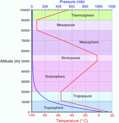
The Earth's atmosphere contains several different layers that can be defined according to air temperature or chemical composition. The atmosphere can be split into distinguishable layers, called the Troposphere, the Stratosphere, the Mesosphere and finally closest to space the Thermosphere. 

Troposphere
It contains all of the elements vital to life, plus most of the water vapour in the atmosphere, most of the clouds, dust and pollution. Most weather happens here.

The temperature decreases rapidly with increasing distance from the Earth’s surface. This is largely because the Earth is heated from the surface outwards, as it receives incoming solar radiation as UV rays which is converted to heat at the surface. Pressure also decreases with height in this zone, and the amount of Oxygen available decreases.

The top of this layer is marked by the TROPOPAUSE, where temperatures remain constant, (isothermal).
Stratosphere
Temperatures increase with height as ozone absorbs the UV. The layer is free of dust and cloud and ozone not only absorbs but filters out UV. 

The upper layer is known as the STRATOPAUSE another isothermal layer.

The Stratosphere does have winds, but these are light in the lower layers and increase in strength with height.
Mesosphere
Temperature decreases to -90. No water vapour or dust to absorb radiation. Very strong winds at 3000 km/hr. Topped by another isothermal layer, the MESOPAUSE.
Thermosphere
Temperatures increase to 1,500 C due to the absorption of UV radiation by atomic oxygen.

Wednesday 6 May 2015

Plate Tectonics- Vulcanicity Case Study

Mt Etna, Sicily, Italy, 1991-1993

Location

  • Mt Etna is located on the island of Sicily in Italy. Italy is an MEDC and had a GDP per capita of over $20,000 in 1991.
  • More than 25% of the population of Sicily live on the flanks of Mt Etna.
  • The lava from previous eruptions provide fertile soil for growing citrus fruit and vines, Mt Etna itself is a tourist attraction and has ski slopes. 
  • Mt Etna is the largest volcano in Europe – it is a stratovolcano which has formed on top of an ancient shield volcano which creates a wide variety of eruption types.

Causes

  • Mt Etna is located on a destructive plate margin between the African and Eurasian plates. 
  • The northern edge of the African plate is being subducted.
  • The eruption in 1991 started on 14th December and lasted for 473 days which was the most voluminous eruption from Etna in over 300 years (250 million m³)
  • The lava flowed down the SE flank of the volcano into the Valle del Bove.
  • The acidic lava had a low effusion rate (rate and volume of lava emitted in m³/sec) which posed very little threat to human life.

Impacts

Social:
  • There were NO deaths as a result of the eruption.
  • The lava destroyed the springs which provided the water supply to the town of Zafferana with a population of 8,000 people.
  • Several people who lost homes and farm land in the Val del Bove blamed the government for not acting soon enough.
  • In interviews made during the late 1990s with people from the Zafferana area,when asked about their fear of a future eruption, many of them expressed that they had no fear because "when there will be a lava flow it will be diverted anyway".
Economic:
  • The total cost of the management and responses as well as insurance claims for damage to property ran into millions of Lira.
Environmental:
  • Vineyards and Chestnut orchards were destroyed

Management & Response

Immediate/short term:
  • During 1992 the Italian authorities built an earth barrier over 400 metres long and 20 metres high in order to stop the lava reaching the town of Zafferana – this contained the lava for about a month before overflowing. 3 smaller embankments were then built.
  • The US marines then became involved in ‘Operation volcano buster’ in which they used explosives to blast a hole in the lava tube and then used helicopters to drop concrete blocks into the main lava flow in order to slow down the lava. 
  • Finally, a diversion channel was dug and explosives were used to divert the lava onto an adjacent flank of the volcano. 
  • The overall outcome of these interventions resulted in the lava flow stopping 850 metres from Zafferana but some geologist argued that the eruption was ending anyway.
Long term:

The Institute of volcanology in Sicily (INGV) has continued to improve methods of monitoring since the 1992 eruption by:
  • Measuring radon gas to detect lava movements within the volcano
  • Using GPS to examine changes in slope angle of the volcano 
  • Using highly sensitive seismometers to measure minute tremors which might indicate lava being forced into the volcano
  • The responses involved many different organisations including the police, fire brigade, the civil defence department, the local council, geologists, volcanologists, the Italian army, Italian Red Cross and the US army.

Plate Tectonics- Vulcanicity Case Study

Soufriere Hills Volcano, Montserrat 1995/7+

Location

  • The Soufriere Hills volcano lies in the small Caribbean Island of Montserrat in the Antilles Islands. 
  • The Island is a British Protectorate and lies to the SW of Antigua. 
  • The Island at its largest is no more that 12km by 8km and before the eruption had a population of 11,000.

When?

  • The current eruptive phase began on 18th July 1995 when large billowing clouds of ash and steam erupted from Soufriere Hills volcano in the south of the island. 
  • The eruption has left the southern two thirds of the island uninhabitable and it remains so to this day. Pyroclastic Flows still pour down the slopes of the volcano. 

Causes

  • The Soufriere Hills volcano is situated above a destructive plate margin, or subduction zone which forms the Puerto Rico Trench. 
  • Oceanic crust from the North American plate is sinking under the Caribbean plate, forming the Antilles volcanic island arc. As the slab of crust descends, sediments, water and the heat of the mantle cause the wedge of mantle above the slab to melt. The molten rock is less dense than the surrounding crust and rises to the surface. The magma formed at a depth of around 6km, with a temperature of 820–885°C, and then partially crystallised before a new injection of deep magma boosted it towards the surface. 
  • The volcano is a strato volcano, composed mainly of consolidated ash layers from previous eruptions. Initially pyroclastic flows flowed eastwards from the open crater down the Tar River valley, but as the dome grew, eventually flows were able to come down any side of the volcano. 

The Primary Effects of the Eruption

  • 2/3 of the island was covered in ash
  • 50% of the population were evacuated to the north of the island to live in makeshift shelters
  • 23 people died in 1997
  • Plymouth - the capital became a ghost town
  • The airport and port were closed
  • Farmland was destroyed
  • Many schools and hospitals were destroyed

The Secondary effects of the Eruption

  • As most of the southern area was destroyed any remaining inhabitants have had to endure harsh living conditions in the North.
  • Transport remains a problem for people travelling to the island as the port and airport remain closed.
  • The tourist industry is still suffering with few visitors except for cruise ships looking at the volcano
  • Over half the population left the island and have not returned
  • Floods as valleys were blocked with ash
  • Forest fires caused by pyroclastic flows

Response

  • £41 million was given in aid by the British Government.
  • Money was given to individuals to help them move to other countries.
  • Riots occurred as locals complained that the British were not doing enough to help the island
  • The MVO (Montserrat Volcano Observatory) was set up to study the volcano and provide warnings for the future
  • A Risk assessment was done to help islanders understand which areas are at risk and reduce problems for the future.

Hazard Management

Once the volcano was deemed dangerous to life, evacuations plans and Hazard maps were put into place. As the eruption progressed the zones were modified until the southern two thirds of the island were declared an exclusion zone.

Monitoring
  • An extensive seismograph network was established around the volcano to measure earthquake strength and depth. 
  • Earth deformation meters and tilt meters were also put in place to show any signs of the ground swelling or deflating as magma rose within the volcano.
  • A satellite location GPS (global positioning system) was also used to check ground movements.
  • An instrument called COSPEC was used to measure gas emissions from the volcano, particularly sulphur dioxide which is a good indicator of magma type and movement.
  • The pH of rainwater was monitored as it gives an indication of the magmatic gas content.

Plate Tectonics- Vulcanicity Case Study

Mt St Helens, USA 1980

Location

  • Mount St. Helens is an active stratovolcano in Washington, in the Pacific North West region of the United States. 
  • It is a composite volcano. It is located 96 miles South of the city of Seattle, and 53 miles North East of Oregon.
  • It is close to the subduction boundary of the North American and Juan de Fuca (oceanic) tectonic plates.

Causes

  • Mount St. Helens is part of the Pacific Ring Of Fire that includes over 600 active volcanoes.
  • Mt St Helens erupted after many months of build-up activity including a massive bulge growth on the side of the mountain.
  • The first indications of a major problem came on March 20, when a 4.2 magnitude earthquake was recorded beneath Mt. St. Helens. Three days later another 4.0 M was recorded, and that evening the earthquakes began occurring in swarms centred directly beneath the volcano, at a rate of about 15 per hour. By March 25, magnitude 4 events were shaking Mt. St. Helens at a rate of about 3 per hour. 
  • The eruption began during a relatively quiet period in which no steam explosions had occurred for four days. On May 18, at 8:32 a.m., a 5.0-M earthquake triggered a very rapid series of events. 
  • The entire northern slope above the bulge failed and the north flank of the volcano
    began to slide downward from almost the exact site of the east-west fracture at the summit. This gigantic landslide released a tremendous mass from above the hydrothermal system that had driven the precursor steam eruptions. 
  • The abrupt loss of confining pressure above the heated groundwater caused a massive flashing to steam, which initiated a hydrothermal blast that was directed laterally through the landslide scarp. The lateral hydrothermal blast rapidly overtook the avalanche and devastated a fan-shaped area to the north, which was nearly 30 km wide over a distance of 20 kilometers. Trees were blown down like matchsticks.

Impacts

Social:
  • Power supplies were cut off and that ash got into water supplies. Consequently, it led to contamination of the water and the spread of disease. 
  • Loss of jobs in logging industry.
  • 57 people were killed, 250 homes, 47 bridges, 15 miles of railways and 185 miles of highway were destroyed.
Economic:
  • This was the deadliest and most economically destructive volcanic event in the history of the United States.
  • Forest destroyed- This would have a great effect on the logging industry because there would not be as many trees for them to cut down. 
  • Lodges would have had to be closed down. This would have an impact on the economy because if the lodges were closed down then there would be nowhere for tourists to come and stay there for they would lose money. 
  • Ash settled 15cm deep this would have an effect because when it rained you would get lots of mud flows and it will but growing trees or crops for next year very hard.
Environmental:
  • 1300 feet was blasted off the top of the mountain. This would have a great effect because that would all break up into ash and encircle the Earth, which would stop heat and light from the sun coming into the atmosphere. 
  • 230 square miles of forest burned and got destroyed. This it would have a great effect on wildlife as 1000s of animals' homes would have been destroyed.

Response

  • An immediate response to the eruption was evacuation. Other residents, who were more on the outer section of the blast zone, were evacuated on several premises such as hotels, campsites and research stations. 
  • One man, an 84 year old innkeeper by the name of Harry Truman, became ‘famous’ after solidly refusing to leave. Part of the evacuation team and local authorities were desperately trying to persuade him, but he simply decided not to, claiming that he had lived there since he was 30 years of age.
  • Locals witnessing the event called emergency services. The Federal Emergency Management Agency arrived not too long after, once permission had been granted owing to the vast situation. They brought with them helicopters, but unfortunately found them less helpful than they thought they would be. 
  • Nevertheless, the emergency services reduced the amount of casualties and with the help of aid agencies, set up temporary rescue centres for those left homeless.
  • Volcanic investigators and geologists also fled towards the scene, in order to proceed in as much research as possible. And because of the great amount of settling ash, street plows were called out and whilst on patrol, were advising people to stay indoors.
  • Following the 1980 eruption a long-term response took place; the area was left to gradually return to its original state. And in 1982, President Ronald Reagan established the Mount St. Helens National Volcanic Monument, with a 100,000 acre area around the mountain.

Plate Tectonics- Vulcanicity Case Study

Nyiragongo, Democratic Republic of Congo, 2002

Location

  • Mount Nyiragongo is about 20 km north of the town of Goma and Lake Kivu and just west of the border with Rwanda
  • Located in the African Rift Valley, where the crust is very brittle along fault the line 
  • Mount Nyiragongo’s main crater is 2 km wide and 250m and usually contains a lava lake. 

Causes

  • Mt. Nyiragongo’s lava its high temperature, basaltic lava, which is very fluid and is known for running down at speeds greater than 90km/h, which makes it extremely hazardous. 
  • Prior to the January 2002 eruption there had been some seismic activity in the area, but the eruption was unexpected

Size of eruption

  • Fairly small eruption 2-4 VEI the impact was much greater because of the political history between DRC and Rwanda 

Short term effects

  • The lava destroyed many homes as well as roads and water pipes, set off explosions in fuel stores and power plants.
  • Commercial centre of town destroyed, three healthcare centres and one hospital.
  • People walked over the lava to escape Goma, by tying strips of cloth over their feet to protect them from burning. However there were horrific burns to limbs.
  • Over 1/3 of Goma destroyed.
  • Water and power supplies and many of the medical facilities including three health centres and one hospital as well as lava covering the northern third of the airport runway. 
  • 147 people were killed 
  • Over 350,000 people fled the area. 

Long term effects

  • Those who did flee to Rwanda found that there was a problem with food and shelter provision in the small country there was also the worry of cholera and diarrhoea due to cramped conditions.
  • There was also limited drinking water; this meant that many people suffered from dysentery.
  • Medical supplies were limited because of the effects of smoke and fumes from the lava which caused eye irritation and respiratory problems as well as burn treatment for those who had crossed the lava. 
  • 220,000 homeless refugees crossed into Rwanda 
  • Lots of refugees returned to Goma because there was little food and poor shelter in
    Rwanda, so they thought they might have a better chance at returning home.
  • Goma had been a tourist resort with hotels overlooking the lake. It suffered an economic downturn for the next 2-3 years as the tourist trade collapsed with few visitors.

Environmental:

  • Sulphurous lava entered Lake Kivu polluting the lake- a major source of drinking water in the area 
  • It also caused methane gas to be released from the lake – which suffocated many people who were camped on the banks of the lake.

Responses

  • Warnings of the lava flows were given and allowed most people to flee their homes. 
  • Aid agencies have given bedding, equipment to provide clean water for drinking and sanitation, blankets, tents, food, and cooking utensils 
  • UN humanitarian aid 
  • Aid was also given in the form of blankets, household utensils, temporary shelter, clean water, sanitation and healthcare which cost the UN over $15 million 
  • Rebuilding Goma was much greater and there was high unemployment in the area as many businesses had been destroyed in the lava flows

Plate Tectonics- Vulcanicity Case Study

Eyjafjallajökull, Iceland, 2010

Location

  • Eyjafjallajokull is a volcano 1660m high in the south of Iceland 200km from the capital of Reykjavik.
  • Eyjafjallajökull is a small volcano (about 40km2) within the chain of volcanoes in the SE Rift Zone.
  • Situated on top of the Mid-Atlantic ridge and a constructive margin and a hot spot which makes eruptions more common. 

Causes

  • On the Mid Atlantic ridge, the convection currents are driving apart the North American plate  and the Eurasian Plate along a constructive plate boundary. This has created a chain of volcanoes along the SE Rift zone of Iceland, which runs from NE to SW across Iceland, even passing underneath some of the countries Ice caps. 
  • Ice cap caused the lava to cool quicker creating larger silica particles 
  • Melt water from the ice cap flowed back into the crater causing more violent eruptions

Size of eruption

  • Fairly small eruption 2-4 VEI the impact was much greater than expected because of the ash cloud.

Impacts

Social:
  • The people in rural areas ‘downwind’ of the volcano had to wear goggles and facemasks. 
  • 700 people had to be evacuated from the area around the volcano, and many of the roads surrounding the volcano were shut down. 
  • Internationally: the winds redistributed the ash that was pumped high into the atmosphere over Northern and western Europe and stopped flights from taking off by clogging their engines. It interrupted not just European flights but also Trans-Atlantic flights. 
  • During the main 8 day travel ban around 107,000 flights were cancelled accounting for 48% of total air traffic and roughly 10 million passengers. 

Economic: 
  • In total Europe lost $2.6 billion of GDP
  • This also has a knock on effect on International flights globally as they could not land or take off from Europe. This is thought to have cost Airlines and associated businesses were losing about £130 million a day (according to the IATA), whilst hundreds of thousands of people were stranded in other countries. 
  • Hire car companies and other forms of transport increased their prices, people had paid thousands of pounds to hire a car to get them to Northern France to take a ferry. 
  • LEDCs were also badly affected, with Kenya being a great example. 20% of the Kenyan economy is based on the export of vegetables and flowers to Europe. These are perishable goods and they are transported by plane to keep them fresh but the flight ban meant that products returned unsold and destroyed. Over 1 million flower stalks were unsold in the first two days and over 50,000 farmers were temporarily unemployed as their beans and peas could not be sold. 
Environmental:
  • The ash contaminated local water supplies and farmers near the volcano were warned not to let their livestock drink from contaminated streams and water sources, as high concentrations of fluoride from the ash mixed with river water can have deadly effects, particularly in sheep. 
  • The Eyjafjallajökull eruption put up to a maximum 30000 tonnes per day of CO2 into the air.

Responses

  • Responses were entirely DOMESTIC. The countries affected had the capacity to respond without aid. Their legal, technical and infrastructure systems could cope with the eruption, even if there are economic impacts.
  • More research has been done in to the effect of ash on airplane engines. It has been discovered that all flights don’t need to be grounded, planes are just required to fly at a lower height.

Plate Tectonics- Vulcanicity

Intrusive activity

With all volcanic regions, the majority of magma never reaches the surface but cools to form coarser grained igneous rocks beneath the ground. 
To form intrusive activity, magma cools slowly under the surface and changes the local rock forming metamorphic rocks, harder rocks and a metamorphic aureole surrounds this with precious metals such as gold zinc, tin and lead.

Features of Intrusive activity

Batholiths
  • A Batholith is a large body of igneous rock formed beneath the Earth’s surface by the intrusion and solidification of magma.
  • Deep seated
  • Surrounded by hot rock the magma cools slowly
  • Large crystals form 
  • Large metamorphic contact zone. 
  • E.g. Cornubian batholith; Dartmoor. Granite is only exposed due to erosion. 
Dyke
  • A vertical intrusion with horizontal cooling cracks. 
  • Cools rapidly on contact with surrounding colder rock. 
  • Contracts and cracks, cuts cross bedding planes 
  • Not usually visible as are small scale intrusive features. 
  • Sometimes a swarm of dykes will form
  • E.g. Isle of Arran- Kildonan shore a sandy beach with parallel walls of igneous rock acting like groynes
Sill
  • A horizontal intrusion along bedding planes with vertical cooling cracks. 
  • Cools rapidly on outside on contact with surrounding rocks. 
  • Contracts and cracks. 
  • These are not usually visible 
  • E.g. Great Whin Sill, UK
Laccolith
  • When magma cools and solidifies along the bedding plain 
  • The volume of magma forces the overlying strata into a dome
  • Visible at the surface as a small hill. 
Lopolith
  • Magma cools and solidifies along the bedding plain between strata
  • Underlying strata to warp downwards.